Wetland delineation is all about pinpointing, assessing, and charting wetlands on a property, which involves several different types of work. From consultations with regulatory boards, to data analysis, environmental engineers can identify the presence of wetlands — before investing in the wrong property.
During this article, we’ll discuss:
- What are Wetlands?
- Wetland Delineation Explained
- The Methodology and Costs
- Noteable Wetland Delineation Reports
- How Wetland Delineation Should Be Conducted
You will also find out more about our Wetland Delineation Services, and how to select a reliable and experienced team for your next development project.
Let’s dig in.
What is a Wetland?
According to the U.S. Fish and Wildlife Service, wetlands are:
“Lands transitional between terrestrial and aquatic systems, where the water table is usually at or near the surface, or the land is covered by shallow water.”
A federal wetland must possess one or more of these three attributes:
- The land supports plant species (hydrophytes) adapted to live in wetlands
- The surface is predominantly undrained wetland soil
- The area is non-soil, saturated with water, or covered by shallow water at times
Florida Department of Environment Protection
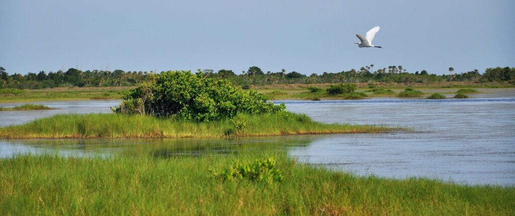
Florida wetlands can be described in a similar way; they would be classified as having prevalent vegetation, and areas that are saturated by surface water. A typical Florida wetland might include:
- swamps
- marshes
- strands
- wet prairies
A wetland evaluation and delineation can help to determine whether this is indeed the case.
Wetland Delineation Reporting
Wetland delineation evaluates the characteristics of a site, including soil, species, plants, and topography to determine the presence of wetlands.
A wetland delineation report establishes the existence and size of a wetland in accordance with local, state, and federal regulations. The process pinpoints if water bodies and boundaries fall into Waters of the United States, which are regulated under the Clean Water Act.
This delineation manual from the Florida DEP (our state’s regulatory authority) outlines everything you need to know about wetland delineation in FL and the importance of this permitting process.
Wetland Identification Methodology
So, how does an environment team identify a wetland during delineation? Usually, they’ll be on the lookout for these three key signs:
1. Vegetation
Wetland plants, or hydrophytic vegetation are types of plants that have adapted to growing in the water. In this low-oxygen environment within anaerobic soil, they use alternative methods of collecting oxygen to grow and thrive.
Here’s the Florida DEP’s Key to Florida Wetland Plants that can be identified during an on-site analysis.
2. Hydric Soil Field Indicators
Another key characteristic of a wetland is when the soil is continually saturated for long periods of time, especially during the growing season. When hydric soils are present, this is a clear sign of a wetland.
The U.S. Natural Resources Conservation Service (USDA-NRCS) has standardized several field-test indicators to recognize when hydric soils are present. Some of these include the Munsell Soil Color Chart, or a detailed evaluation of the texture and structure of the soil sample. You can even notice a “rotten egg” smell when hydrogen sulfide is present, which suggests anaerobic conditions.
3. Hydrology
The term “hydrology” refers to the amount of flooding or soil saturation within the wetland site.
The position within the landscape, quantity of rainfall, and soil absorbency can affect the hydrology of a wetland. Indicators of wetland hydrology are the most important factors, but often the hardest to determine since water levels can vary depending on the time of year.
U.S. Army Corps of Engineers Wetland Delineation Manual
This useful manual was designed to provide readers with guidelines and methods for determining whether an area is a wetland.
The Army Corps of Engineers Wetland Delineation manual is definitely worth a review, if you’re interested in finding out more about the history, and real-life examples of delineated wetland boundaries. It’s a crucial part of developing foundational knowledge on aspects of wetland conservation.
Practical Tips to Avoid Environmental Risk on all Your Projects
A lot of time, care, and effort goes into planning a development project, so it’s important to be aware of the environmental risks you may face along the way. Consider these tips to ensure a seamless project (and compliance with all regulations):
- Start your preliminary site assessments early, and understand laws and guidelines.
- Carry out a desktop review to pinpoint potential habitats, bird nesting, or jurisdictional waters (sooner rather than later).
- Use wetland mitigation and minimization strategies if there is presence in the area.
- Find a certified wetlands team to conduct a thorough survey of the area to confirm or deny the presence of species.
- Inform construction teams to avoid any protected species or nests during the project.
- Work with an environmental engineer to obtain an elevation certificate, topographical survey, or flood study if the project crosses a floodplain.
This checklist will be useful when it comes to avoiding environmental risks for your project, because you’ll want to work with a reliable team who has experience working in these types of environments.
Why Wetlands are Protected: The Clean Water Act and Water Quality Protections
Wetland Boundaries and Jurisdictional Determination: Waters of the United States
Wetlands are protected under the Clean Water Act as they form part of the Waters of the United States. To provide quality drinking water and home to important species, wetlands must be protected. The loss of wetlands doesn’t benefit anyone long-term.
Certain states also have their own wetland regulations. Take a look at the Florida Wetlands Delineation Manual for further insight into Florida’s specific rules on wetland protection.
When to Do a Wetland Delineation
A wetland delineation is a legal requirement when a wetland is discovered on a property in the development process. Any project that may impact a wetland requires a wetland delineation, and a permit must be received to approve the boundary.
How to Conduct Wetland Delineation
There are three key stages in which a wetland delineation should be conducted:
- Hire a Wetland Professional
Working with an experienced firm will help you determine the presence of a wetland during your project. They can assess the site thoroughly, inform developers, and mitigate any environmental hazards on site.
- National Wetlands Inventory
This is a useful tool that can be used for wetland mapping. Accessing this tool may help you discover potential areas and boundaries of a particular wetland. However, it doesn’t provide in-depth information that must be obtained from an on-site specialist.
- Due Diligence Software
Due diligence software provides information regarding location and data on protected wildlife, presence of water and other important site elements. This can help to identify potential challenges early on in development, but will require additional research.
How Long is My Wetland Delineation Good For?
After it has been approved, a wetland delineation is valid for five years. This allows developers to work towards their project with plenty of time to avoid extra expenses along the way.
What is the Difference Between Wetland Delineation and Wetland Reconnaissance?
Wetland Delineation
A legal requirement involving an in-depth study and wetland delineation report when highly-sensitive waters are situated on a property. This is in accordance with U.S. Army Corps guidelines.
Wetland Reconnaissance
Acts as an initial evaluation tool to discover if protected habitats, species, and waters are present in the area. This is particularly useful during the process of site selection.
This is just the first check that helps to find out if there are any protected or sensitive wetland features on a property. If a wetland is found, then a delineation is necessary.
How Much Does Wetland Delineation Cost?
Wetland delineation costs can vary from project to project, but you can average out the expense according to the size of the site. With wetland delineation, the larger the area, the bigger the cost will be. A conventional wetland delineation might cost around $800 on a site that is smaller than five acres. Whereas, a bigger site could go up to $25,000 depending on the conditions and the fees of the consulting company.
What is Wetland Mitigation?
Wetland mitigation is the process of restoring, improving, and adapting a wetland to compensate for any disturbance to the land. This is usually done to stop serious wetland impacts on rare ecosystems.
Under Section 404 of the Clean Water Act, there is an obligation for these mitigation plans to take place when a wetland is destroyed. Once mitigation plans are put in place, the NRCS must then approve them and allow the plans to be put into motion.
Learn More About Our Wetland Delineation Services
At the end of the day, your state and federal environmental agencies are the final word on where wetland delineation is established.
But, you’re going to want a guide to help you get through the process as painlessly as possible — so your project budget doesn’t go haywire. Creek Engineering is a leading Geotechnical and Environmental firm in SW Florida, and we provide multiple site investigation services under one roof.
Contact us today to learn more about our wetland delineation services here, and find out how to get top-tier engineering services for your SWFL building project. You can speak directly with our professional engineering team.